


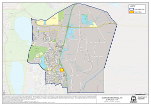
The following defines the local-intake area of Baldivis Secondary College from 2019:
From the junction of Mandurah Road and Millar Road West, east along Millar Road West and the local government boundary of the City of Kwinana and the City of Rockingham, continuing east along the local government boundary of the City of Kwinana and the City of Rockingham to the junction of Duckpond Road, south east along Duckpond Road (south west side included) to Mundijong Road and the local government boundary between the City of Rockingham and the Shire of Serpentine – Jarrahdale, south west along this local government boundary to its junction with the Serpentine River, south from this junction to a point on the eastern extension of Serpentine Road, west from the aforementioned point to Serpentine Road, west along Serpentine Road (north side included) to the Kwinana Freeway, north along the Kwinana Freeway (east side included) to a point on the eastern extension of the east-west arm of Furioso Gardens, west along Furioso Gardens (north side included and including 36 Furioso Gardens) to Baldivis Road, north along Baldivis Road (east side included) to Highbury Boulevard, south west along Highbury Boulevard (north side included) to Portman Parade, north along Portman Parade (east side included) to Bramall Terrace, south west along Bramall Terrace (north side included) to Makybe Drive, north along Makybe Drive (east side included) to Blaxland Terrace, west along Blaxland Terrace (north side included) to the intersection of Nairn Drive, Wise Meander and Blaxland Terrace, north along Nairn Drive (east side included) to Safety Bay Road, north west and west along Safety Bay Road (north side included) to Mandurah Road and north along Mandurah Road (east side included) to Millar Road West.
Map
Click here for an interactive and searchable map.
Click on map to view PDF version.